
Home > Apps > Maps & Navigation > スーパー地形 - GPS対応地形図アプリ

| App Name | スーパー地形 - GPS対応地形図アプリ |
| Developer | kashmir3d |
| Category | Maps & Navigation |
| Size | 16.7 MB |
| Latest Version | 4.6.17 |
| Available on |
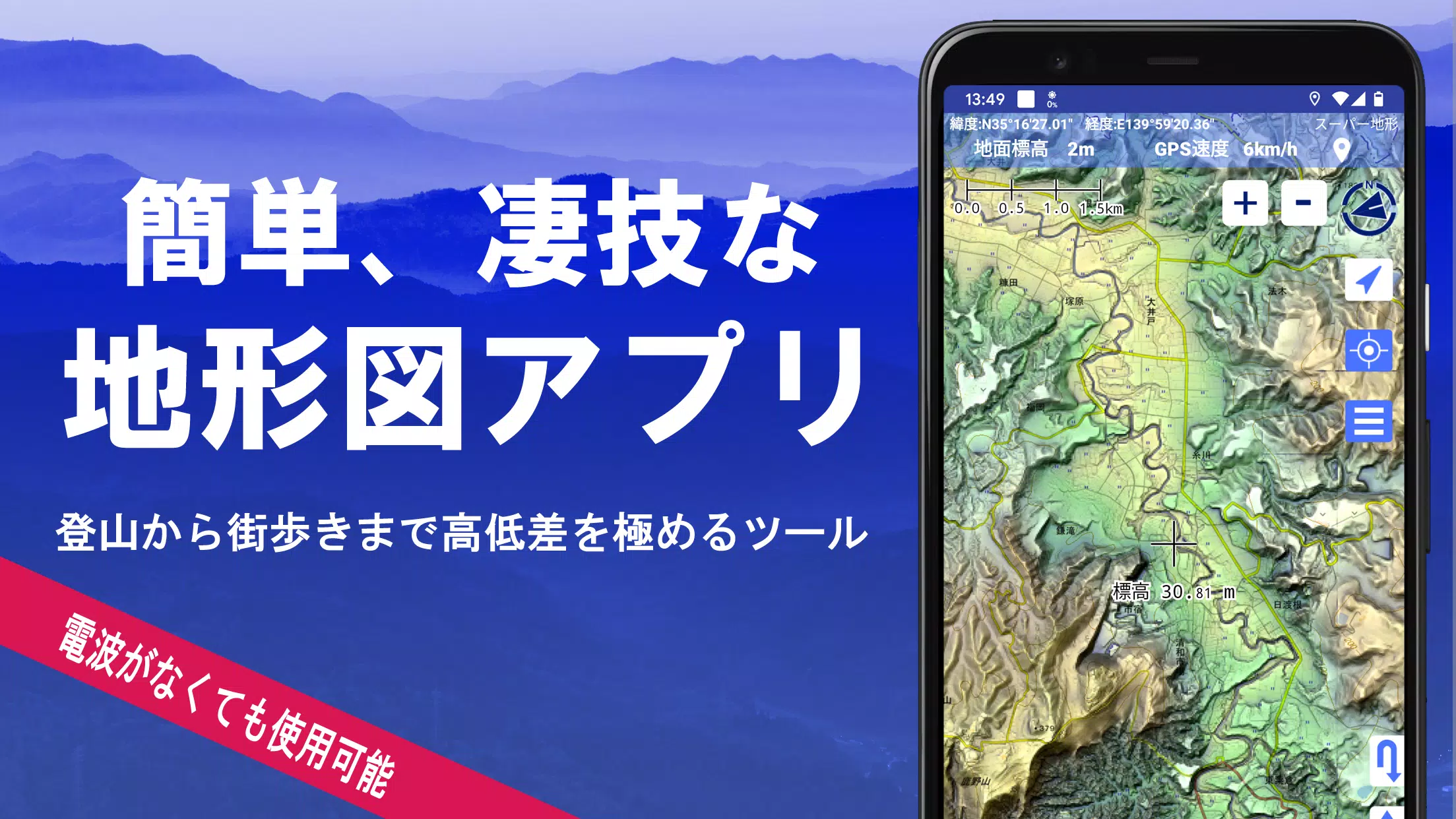


With over 100 types of maps at your fingertips, including the Geographical Survey Institute map, you can explore everything from mountain climbing to strolling through urban landscapes. These maps allow you to maximize the benefits of elevation differences, enhancing your outdoor experiences.
Super Terrain was honored with the 2018 Japan Cartographic Society Award for Best Work, recognizing its excellence in mapping technology.
- Utilize "super terrain data" that uniquely emphasizes terrain to enhance your navigation experience.
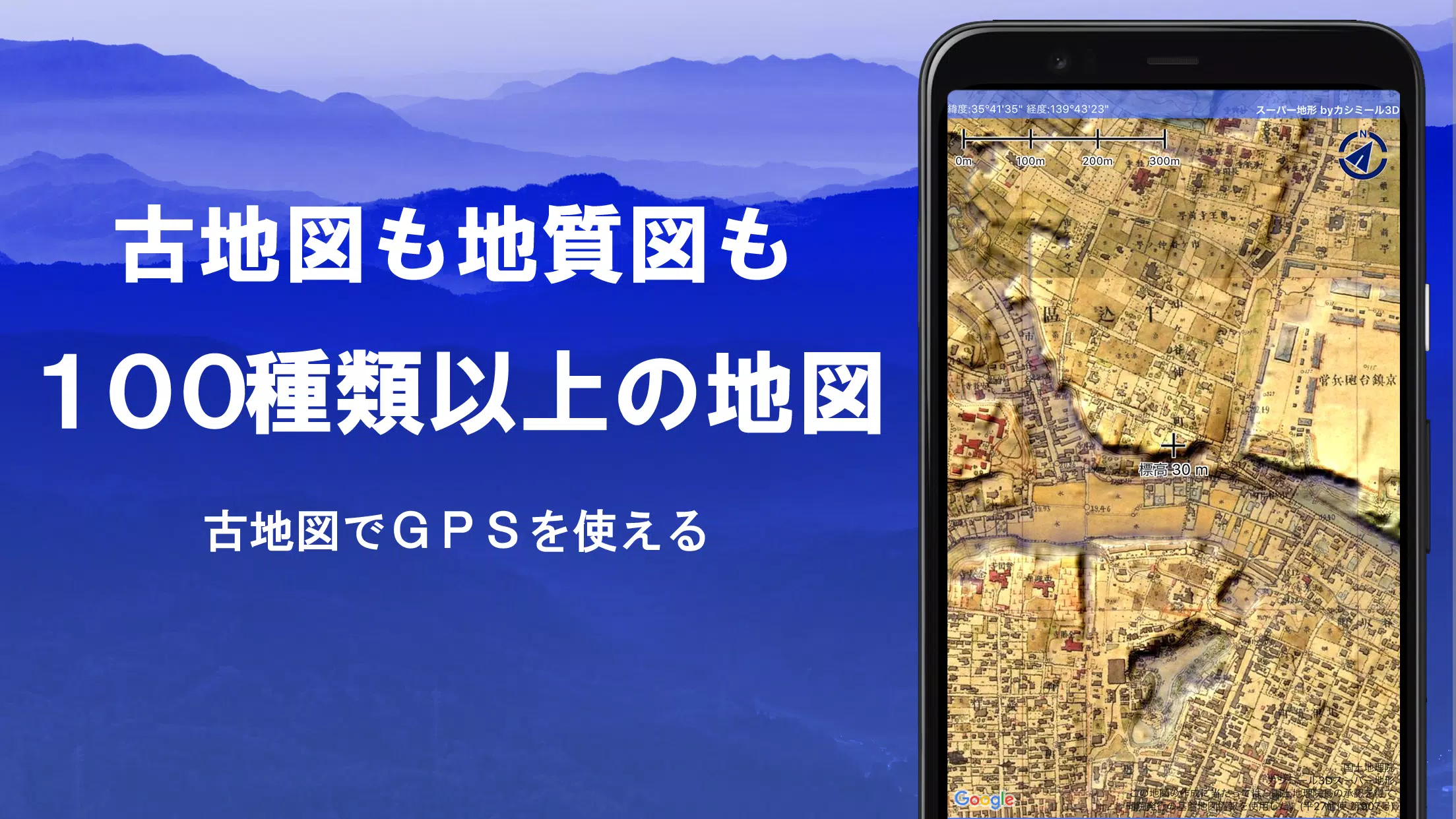
- Access a variety of maps from the Geospatial Information Authority of Japan, including topographic maps, geological maps, old maps, historical and contemporary maps, and prewar topographic maps (Ordnance Survey Department).
- Record your tracks (trajectories) using the GPS function, with GPX log input/output and editing capabilities.
- Benefit from features designed for urban exploration, mountain climbing, and outdoor activities, such as GPS navigation with audio, and data recording and editing.
- Use the visibility determination function for creating cross-sectional diagrams, observation, and radio communications, with the ability to display buildings.
- Enjoy a 360° panoramic view function, which includes mountain identification and displays the sun, moon, and GPS points.
- Experience robust GPS functionality, bulk map downloads, and map caching for seamless offline use during mountain climbing or other outdoor activities.
- Link photos to specific points on the map.
- Visualize contour lines generated from elevation data.
- Display the MGRS grid (UTM grid).
- Read, display, and edit GIS data from GeoJSON files.
- Draw shapes on the map.
- Use the app overseas.
- Print maps and output them as PDFs.
- Enjoy the convenience of a dark theme.
1. A Wealth of Maps at Your Disposal
With over 100 types of maps available, including combinations, Super Terrain offers a comprehensive selection. Our unique super topographic data, maps from the Geospatial Information Authority of Japan, and hazard maps ensure you have the tools you need for any adventure. Note that aerial photographs may vary in availability by age group, with the "latest" and "around 1974" having wider coverage. Maps using super terrain data are available for free for the first 5 days after installing the app.
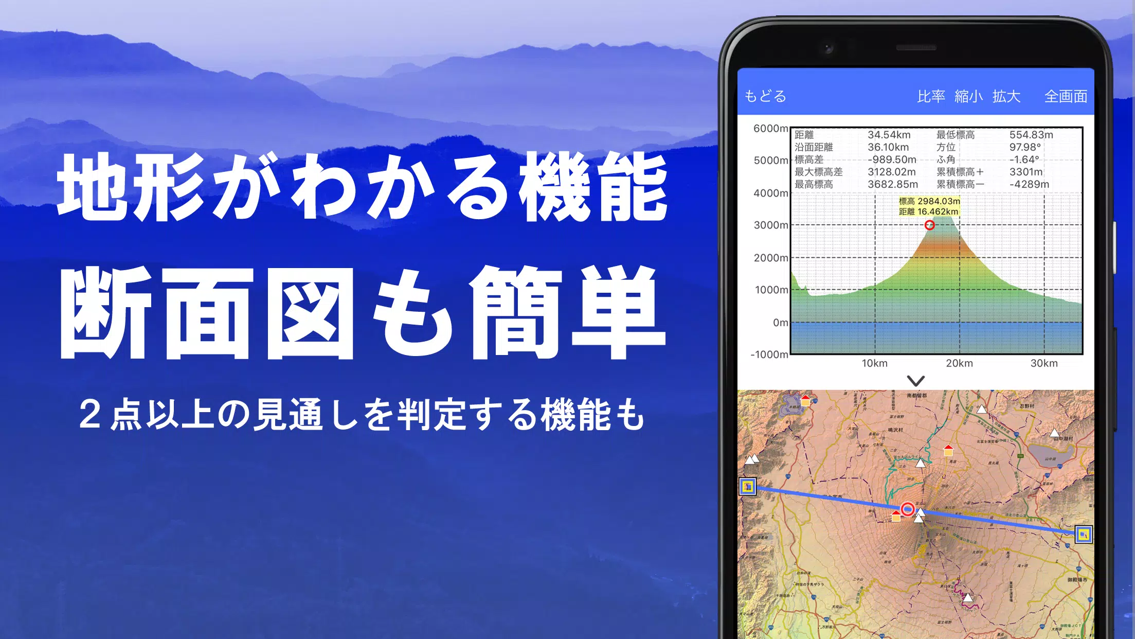
2. Creating Cross-Sections and Outlooks
Effortlessly draw cross-sections through any point on the map. The app features a visibility judgment function from Kashmir 3D, which accounts for Earth's curvature and atmospheric differences. This is invaluable for route planning during climbs, assessing wireless visibility, and understanding terrain. Where PLATEAU building data is available, you can incorporate buildings into your cross-sectional views.
3. Elevation Palette Function
The elevation palette function lets you customize the map's background color, allowing you to set your preferred color gradient in 1cm increments.
4. Panoramic View
The panoramic observation map displays mountain names from any point on the map. With a 360-degree panorama linked to your smartphone's compass, it's perfect for mountain identification. You can also view the sun and moon, including moon phases, which is useful for spotting Diamond Fuji and Pearl Fuji. Display GPS points and even draw panoramic views of mountains abroad.
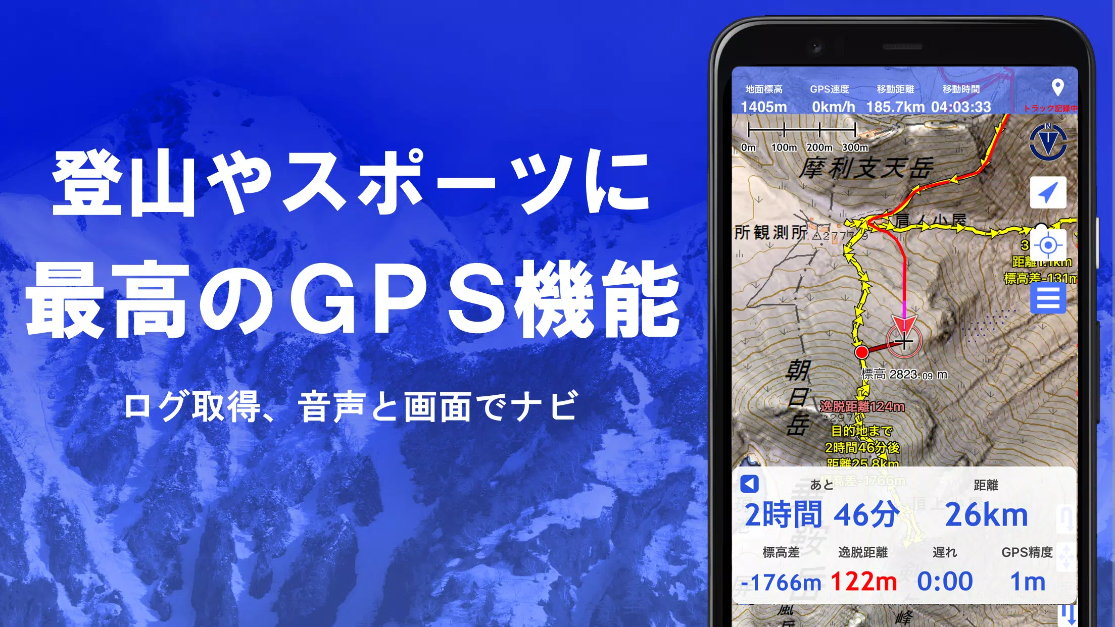
5. GPS Function
Utilize your smartphone's GPS to obtain location information and record tracks. Super Terrain employs high-precision positioning suitable for serious mountain climbing and outdoor activities. Recorded tracks can be graphically displayed with parameters like elevation change, speed, time, and elapsed time. The point alarm function notifies you with voice and alarm sounds when you approach a designated point. Display photos linked to points and send the map center position to NaviCon.
6. GPS Track Summary Playback
This feature allows you to play back your recorded tracks in one go. It automatically displays photos stored on your smartphone that match the track's timeline. An icon appears at the photo's location, which you can tap to view.
7. GPS Navigation Function
Navigate along preset tracks with the Track Navi function, using your smartphone's GPS. If you stray from the track, you'll receive a voice or alarm notification, preventing you from getting lost during climbs. The app also supports route navigation for urban walks and point navigation targeting a single location.
8. GPS Data Editing Function
Manage GPS-related point, route, and track data, organized in folders and displayed in a clear tree format. Create tracks directly on the map and import or export them in GPX format from mountain climbing sites.
9. Map Usage Outside the Service Area (Offline)
Use maps even in areas without a signal, such as during mountain climbs. The bulk download function allows you to download all scale maps of a specified plot, ensuring you have the necessary maps on site. A cache function is also available.
10. Map History Function
The app remembers locations you've viewed, allowing you to return to them easily.
11. Custom Map Compatibility
Import and use custom maps created with Kashmir 3D's map cutter, including your own maps and scanned maps. When using the map cutter, divide images into approximately 256 x 256 pixels and send the created kmz file to Super Terrain via email or Cloud Drive.
12. GeoJSON Compatibility
Display and edit points, linestrings, and polygons from GeoJSON files, and draw new shapes.
13. Print/PDF Output
Print any area of the map at a specified scale or create a PDF.
14. Integration with Other Apps
Input and output GPS data in GPX, KML, and GDB formats, facilitating data exchange with other apps, Kashmir 3D on your PC, and mountain climbing sites.
15. Backup Function
Back up all app data (excluding cached maps) and remove it from your smartphone. Restore data if you delete the app or if your device malfunctions. An automatic backup feature using Google Drive ensures your data is always up to date. For detailed instructions, refer to the manual.
16. Billing Function
Some features, such as maps using super terrain data, GPS track functions, and cross-sectional views, require in-app purchases. After payment, the number of search results for place name searches increases.
- Fees: Annual payment: 780 yen/year
- Free Trial: Enjoy a 5-day free trial after installing the app. After 5 days, certain features and maps will be unavailable unless you purchase them. You won't be charged unless you initiate a purchase.
- Confirmation and Cancellation: Check or cancel automatic updates by opening Google Play, selecting "Regular Purchase" from the menu, and choosing "Super Terrain."
- Price Revision: Prices may change due to future feature enhancements. Purchasing early is advantageous.
17. Terms of Use
The copyright holder and developer are not responsible for the outcomes of using this application. When starting GPS for the first time, you'll be prompted to allow location services. Continuous GPS use will drain the battery, so if your device is used for emergency communication, carry a spare battery. For a detailed explanation of the navigation function, refer to the PDF at https://www.kashmir3d.com/online/superdemapp/superdem_navi.pdf. Note that with some smartphones, track recording may be interrupted due to power-saving features forcibly closing background apps. Turning off the screen while Super Terrain is active may temporarily maintain recording, but this isn't a permanent solution.
-
 2025 Gacha Games: Full Release List
-
 Azure Latch Codes (March 2025)
-
 Black Ops 6 Zombies: How To Configure The Summoning Circle Rings on Citadelle Des Morts
-
 Roblox: SpongeBob Tower Defense Codes (January 2025)
-
 Persona 5: Phantom X Playtest Leaks on SteamDB
-
Chimera Clan Boss Guide: Top Builds, Masteries, and Gear for RAID: Shadow Legends