
Home > Apps > Productivity > ShipAtlas by Maritime Optima

| App Name | ShipAtlas by Maritime Optima |
| Category | Productivity |
| Size | 156.09M |
| Latest Version | 5.0.0 |
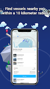
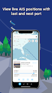


ShipAtlas by Maritime Optima is a must-have app for anyone interested in vessel tracking and maritime activities. With real-time AIS position data from over 700 satellites and terrestrial senders, you can track vessels and get valuable information about trades, port activities, sea routes, marine weather, ice conditions, piracy zones, and marine maps. The app collects raw AIS data for the global merchant fleet every second and processes it to provide you with high-quality data. You can search for specific vessels or ports, calculate sea routes, create vessel lists, set notifications, access daily marine information, and much more. The app offers a user-friendly interface, data synchronization across devices, and a dedicated support chat.
Features of ShipAtlas by Maritime Optima:
- Comprehensive tracking and trade information: Users can access data on port activities, sea routes, marine weather, ice conditions, piracy zones, and marine maps.
- High-quality data: The app ensures the accuracy and reliability of the collected AIS data through data wrangling and cleaning processes.
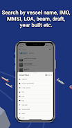
- Vessel search options: Users can search for specific vessels by name, IMO or MMSI numbers, or port names and types. Additional details such as LOA, beam, draft, and year built can be used for more specific searches.
- Sea route calculator: The app offers a quick and easy-to-use calculator that provides estimated time of arrival, distance in nautical miles, time at sea, and estimated bunker consumption for various sea routes.
- Customizable vessel lists and real-time tracking: Users can create unlimited vessel lists based on their search criteria and track the vessels in real-time on the map.
Conclusion:
ShipAtlas by Maritime Optima is a user-friendly app that provides real-time AIS position information and a wide range of tracking and trade-related data. With its high-quality data, easy-to-use interface, and features like the sea route calculator, the app is a useful tool for anyone interested in vessel tracking. While most features are free, users can enhance their experience by upgrading to a paid subscription for access to additional features. Download ShipAtlas by Maritime Optima now to start exploring the world of maritime navigation and information. Visit our website to learn more.
-
NavigateurMay 05,25Indispensable pour le suivi des navires. Les données en temps réel et les informations détaillées sont incomparables. Je le recommande vivement pour l'analyse et le suivi.Galaxy S21 Ultra
-
船长Jan 20,25对于海事行业来说,这款应用是必不可少的。实时数据和详细的船舶信息无与伦比。强烈推荐用于跟踪和分析。Galaxy S24 Ultra
-
SchiffsführerDec 25,24Unverzichtbar für die Schifffahrtsbranche. Die Echtzeitdaten und die detaillierten Schiffsinformationen sind unschlagbar. Hoch empfehlenswert für Tracking und Analyse.Galaxy Note20 Ultra
-
MarineroAug 13,23Una herramienta imprescindible para el seguimiento de buques. Los datos en tiempo real y la información detallada son excelentes. Muy recomendado para profesionales del sector marítimo.Galaxy S22
-
SeaCaptainApr 18,23Absolutely essential for anyone in the maritime industry. The real-time data and detailed vessel information are unmatched. Highly recommend for tracking and analysis.Galaxy S23
-
 2025 Gacha Games: Full Release List
-
 Azure Latch Codes (March 2025)
-
 Black Ops 6 Zombies: How To Configure The Summoning Circle Rings on Citadelle Des Morts
-
 Roblox: SpongeBob Tower Defense Codes (January 2025)
-
 Persona 5: Phantom X Playtest Leaks on SteamDB
-
Chimera Clan Boss Guide: Top Builds, Masteries, and Gear for RAID: Shadow Legends